
LiDAR vs Camera Drones for Inspections: Which Do You Need?
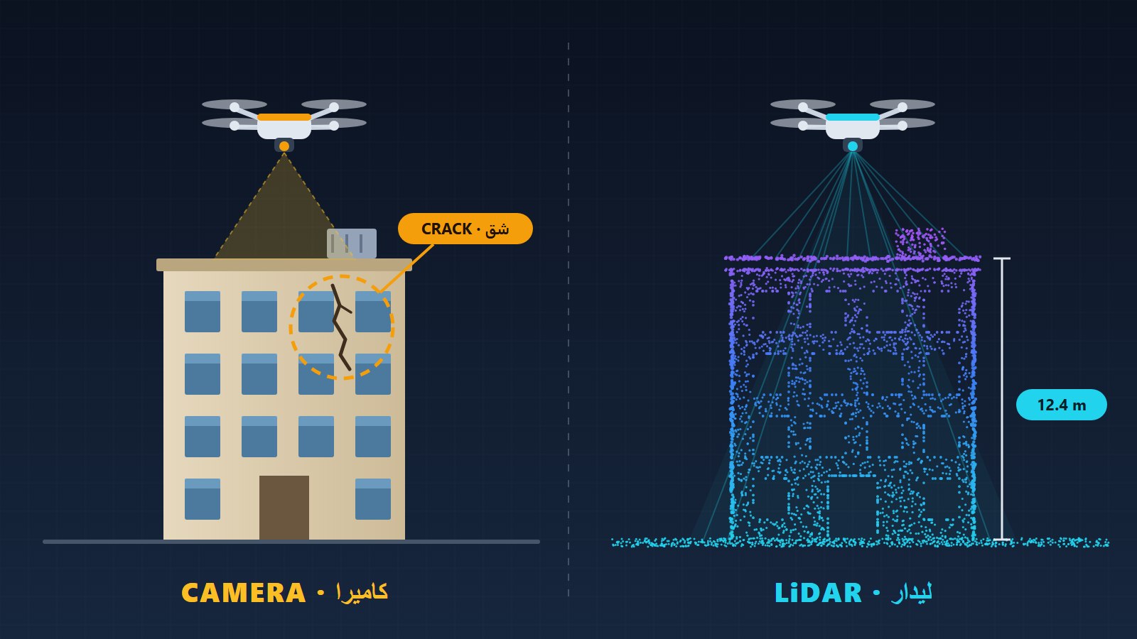
Search for drone inspections and you'll soon read about LiDAR: laser-scanning drones that build centimetre-accurate 3D models. It sounds like the most advanced option, so it's natural to assume you need it. For most buildings, roofs and façades you don't. This guide explains what LiDAR is, how it differs from a high-resolution camera, and how to tell which one your project actually needs.
What is LiDAR?
LiDAR stands for Light Detection and Ranging. The sensor fires hundreds of thousands of laser pulses every second and measures how long each one takes to bounce back. Combined with the drone's exact position, every return becomes a point in 3D space. Together these points form a point cloud: a precise digital copy of the shape of whatever the drone flew over.
LiDAR measures shape and distance. On its own it doesn't record colour or fine surface texture, which is why LiDAR systems usually carry a camera as well to colour the points.
What a camera drone does
A camera drone captures high-resolution photos and video, with optical zoom for close-ups from a safe distance. It records what a person would see standing right next to the problem: hairline cracks, rust streaks, water stains, missing sealant, damaged tiles, loose cladding and sand blocking a roof drain.
Overlapping photos can also be processed into maps and 3D models. This is called photogrammetry. It's useful, but for a visual inspection the photos themselves are usually what matters.
LiDAR vs camera at a glance
| Camera drone | LiDAR drone | |
|---|---|---|
| Best at | Showing condition: cracks, rust, leaks, damage | Measuring shape: exact 3D geometry and distances |
| Output | Photos, zoom close-ups, video, marked-up report | 3D point cloud, terrain and surface models |
| Colour and texture | Yes, in full detail | Not on its own |
| Thin objects (wires, cables) | Visible in photos | Measured precisely, including clearances |
| Through vegetation | No | Partly: pulses pass through gaps in trees |
| Low light | Needs daylight | Works in low light (its own laser source) |
| Cost and processing | Lower; results are quick to review | Higher; needs specialist software and skills |
When a camera inspection is the right choice
If your question is "Is something wrong, and where?", a camera is the right tool. That covers most jobs:
- Roof checks for leaks, cracked waterproofing, damaged tiles and blocked drains.
- Façade checks on high floors for cracks, loose cladding and failed sealant.
- Rooftop equipment such as AC units, water tanks and pipes.
- Before buying, selling or renting a villa or building.
- After a dust storm or heavy rain, to see what changed.
- Progress records on a construction site.
In the Eastern Province, heat above 45°C, coastal humidity in Al Khobar, Dammam and Qatif, and regular dust storms cause exactly these visible problems. Our roof and building inspections guide explains what a camera inspection covers and what you receive.
When you really need LiDAR
If your question is "Exactly how big, how far, or how much has it moved?", LiDAR is worth considering:
- Power line corridors: measuring clearance between lines and trees, buildings or ground.
- Ground levels under vegetation: terrain models where trees or palms hide the ground.
- Precise 3D models of complex structures for engineering or design work.
- Deformation monitoring: comparing scans over time to detect movement or sagging.
- Earthworks and volumes where survey-grade measurements are required.
These are survey and engineering tasks. They need a LiDAR payload, specialist processing software and often a licensed surveyor to sign off the results.
A simple way to decide
- Write down the question you want answered. "Why is the ceiling leaking?" needs a camera. "Is the tower leaning 2 cm more than last year?" needs LiDAR.
- Think about the deliverable. Photos and a marked-up report for a contractor point to a camera. A measured 3D model for an engineer points to LiDAR.
- Check the budget. LiDAR costs more to capture and process. Don't pay for measurements you won't use.
- Ask before you book. A good operator tells you which tool fits, even when it isn't the one they fly.
What we offer
Madar Drone does camera-based visual inspections and aerial photography across Al Khobar, Dammam, Dhahran and Qatif. We don't currently fly LiDAR. If your project genuinely needs it, we'll say so before you spend anything. Our pilots are GACA certified; see what GACA requires for commercial drone work.
Not sure which you need? Send us the location and your question on WhatsApp and we'll tell you honestly.
Frequently asked questions
What is a LiDAR drone?
A drone carrying a LiDAR sensor, which fires laser pulses and times how long each one takes to bounce back. Millions of these measurements form a 3D point cloud: an accurate digital copy of the shape of the ground, buildings or structures.
Is LiDAR better than a camera for inspecting a roof or building?
Not usually. Most building problems, such as cracks, leaks, stains, rust, loose cladding and blocked drains, are visual. A high-resolution camera shows them clearly; a LiDAR point cloud measures shape very well but doesn't show colour or fine surface detail.
When do I actually need LiDAR?
When your question is about exact measurements rather than condition: a precise 3D model, clearance between power lines and trees or buildings, ground levels under vegetation, or movement and deformation over time.
Does Madar Drone offer LiDAR scanning?
No. We do camera-based visual inspections and aerial photography. If your project really needs LiDAR, we'll tell you before you spend anything, so you can hire the right specialist.
Can a drone inspection replace an engineer's assessment?
No. A drone gives the engineer or contractor clear, close-up evidence without anyone climbing. The engineering judgement on what to repair, and how, stays with them.